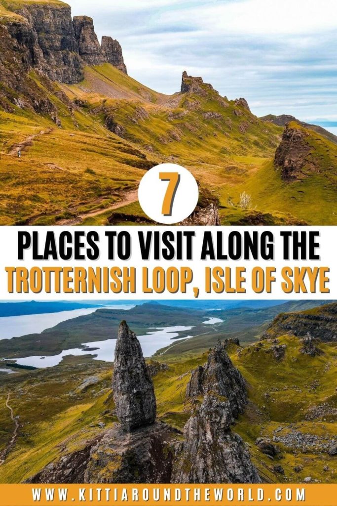
Trotternish Loop: 7 Places to Visit in North-East Isle of Skye
A visit to the Isle of Skye wouldn’t be complete without driving around the island’s most scenic route, the Trotternish Loop.
If you’ve been browsing posts about the Isle of Skye, you’ve probably noticed that a 3-day road trip is possibly one of the best ways to see most of its gems. Since I like to put a little twist on things, instead of your usual 3-day itinerary, I created a 3-part series. This way you’ll find the best detailed itinerary to explore each area of this beautiful place, namely: Central Isle of Skye, North-East Skye (aka the Trotternish Loop) and North-West Skye.
If you’d like to see our road trip around the north-east of the Isle of Skye then make sure to watch our YouTube video by clicking here. You can also watch our full Isle of Skye Adventures by clicking here.
Disclosure: This post may contain affiliate links, which means we may receive a small commission if you click a link and purchase something. Clicking these links won’t cost you anything, but it will help us to keep this site up and running! Learn more about our affiliate policy.
About the Isle of Skye
The Isle of Skye is the largest island in the Inner Hebrides and the second largest in Scotland after Lewis and Harris. Known for its picturesque harbour with colourful houses, Portree is the island’s capital and largest settlement. Many people therefore base themselves in Portree when touring around the island.
The island’s landscape to the south and central areas is dominated by the stunning Cuillin Range. The main range is called the Black Cuillin whereas the eastern hills are called the Red Cuillin. To the north of Portree is the Trotternish Peninsula. Both areas offer some fantastic walking and hiking routes with the Cuillins alone offering 12 Munros. Munros are mountains in Scotland that are over 3,000 ft (914.4 m). These Munros are part of the ‘Munro bagging’ challenge where climbers try to conquer all 282 Munros.
Skye also has a rich history which is full of Dinosaur Fossils, Clan Wars, Highland Clearances, Bonnie Prince Charlie and the Jacobite Rising. Without digging too deeply into the island’s history, I think it’s worth mentioning the two most powerful clans on Skye: Clan MacLeod and Clan Macdonald that had a long-term feud. The clan system came to an end in the 18th century after the Jacobite risings. This was followed by the Highland Clearances that replaced many communities with sheep farms.
The island’s population has declined with only about 10,000 people living there in 2011. According to the 2001 Census data, approximately one third of Skye’s residents are Gaelic speakers. Whilst their number is declining, it’s still an important part of their culture.
I guess it comes as no surprise that Skye’s leading industries are tourism, agriculture, forestry, and fishing.
How to Get to the Isle of Skye
By Car
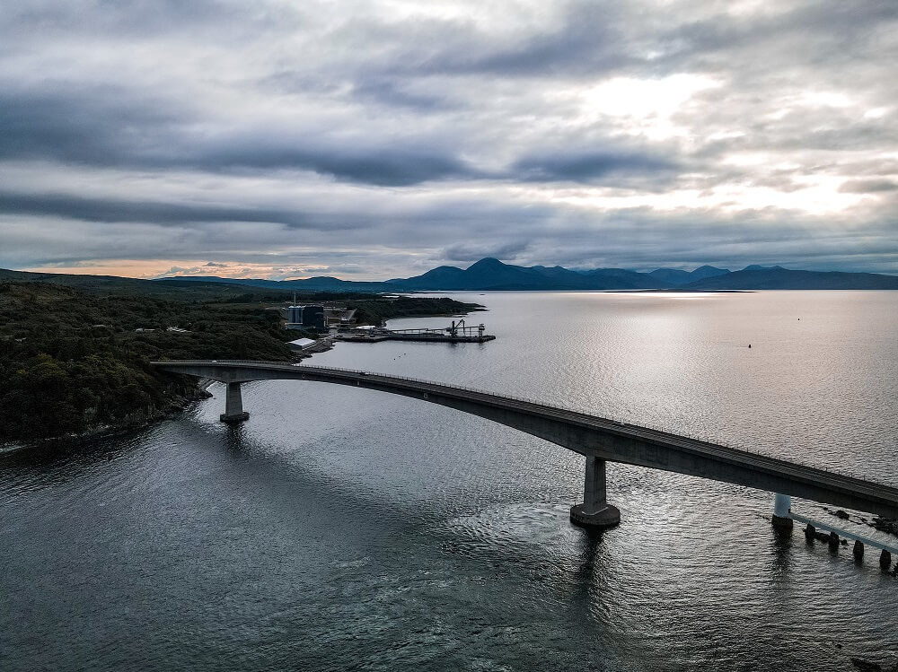
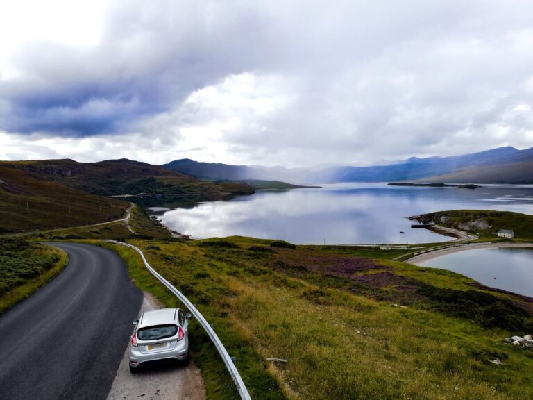
Since 1995 it has been possible to drive to the Isle of Skye from mainland Scotland thanks to the famous road bridge called the Skye Bridge. Until 2004 it operated as a toll road and visitors had to pay approximately £5.70 each way to cross it. When the Scottish Government bought the bridge they removed the tolls, so now you can drive across the bridge for free.
Top Tip – I loved driving across the bridge as it provides you with some stunning views. If you’d like to admire the bridge a bit longer, I recommend you either stop at Kyle of Lochalsh on mainland Scotland or Kyleakin on Skye.
If you don’t have your own car but would like to enjoy the freedom of a private vehicle, then you can always hire a car using this company to get to the Isle of Skye.
By Public Transport
By Bus – You can travel to Portree and Uig by bus from Glasgow or Inverness. You can plan your journey by clicking here. In addition, Stagecoach runs local bus services between villages. You can plan your journey by clicking here.
By Ferry – You can also reach the Isle of Skye by ferry. There are 3 ferry ports on Skye: Armadale, Uig and Sconser. These ferries are run by Calmac and sail to destinations such as Mallaig, Harris, North Uist and Raasay. You can browse for ferries by clicking here.
By Train – If you’re coming from further afield, you can get the train to either Kyle of Lochalsh or Mallaig from where you can take the local bus or ferry. Please note that from Armadale public transport services are less frequent so you might want to reach Kyle of Lochalsh.
What is the Trotternish Loop?
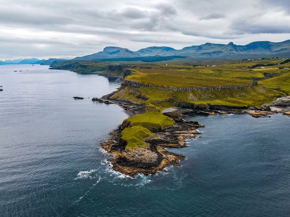
The Trotternish Loop runs around the Trotternish Peninsula on the North-East of Skye. This part of Skye is without doubt home to some of the most beautiful landscapes that can be found on the entire island.
The peninsula’s most iconic feature is the Trotternish landslip, which runs for about 30km (20 miles), making it the largest landslide in the UK. The result of the landslide is the Trotternish Ridge which was created about 11,500 years ago. The ridge is made of soft sandstone below and harder volcanic basalt on the top. The pressure from the hard rock made the soft rock underneath collapse and move. The entire landslip is considered a Special Area of Conservation.
There are 3 major settlements on the peninsula: Portree, Uig and Staffin.
Based on the 2001 Census data, 61% of the population is Gaelic-speaking, making Trotternish the strongest Gaelic-speaking area of Skye.
Luckily, you’ll be able to see most of the peninsula’s main attractions by completing the Trotternish Loop. The loop starts from Portree then circles around the peninsula by following the A855 next to the coast. In Uig, the road joins with the A87 which is the major road that runs through Skye. It takes at least 2 – 2.5 hours to drive around the entire peninsula which isn’t including any stops.
Please Note – Since there are many beautiful places to explore along this loop, unless you’re only stopping briefly for a few photos, you won’t be able to see everything in only one day. This was the reason why we decided to cut the loop slightly short and take the small road that cuts across the peninsula between Brogaig and Uig.
You can find 7 stunning stops below that can easily be visited in just one day without feeling too rushed.
7 Places to Explore Along the Trotternish Loop
Below are 7 beautiful places you should visit whilst driving around the Trotternish Loop. This itinerary is filled with walking trails through the most amazing landscapes combined with stunning views and waterfalls. In addition, if you’re lucky you might be able to find some actual dinosaur footprints.
Note – Since people will likely do a very similar itinerary to yours, you’ll inevitably run into the same people all day long. It’s actually quite fun, so just enjoy the day and don’t forget to say hi to your fellow road trippers.
Top Tip – Start your day early to be able to explore as many places as possible. Plus, this way you will have some of the places almost to yourself at the start of your trip.
For reference, we stayed in Kyle of Lochalsh on mainland Scotland and drove across the Skye Bridge every day. Please be sure to adjust the order of the itinerary according to where you’re staying.
Please Note! – Whatever you bring with you, make sure you either take it home with you or dispose of it responsibly. I suggest bringing a garbage bag with you where you can collect all your waste. Enjoy your time in nature but Leave No Trace!
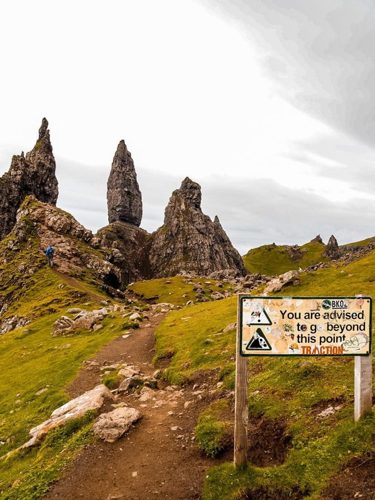
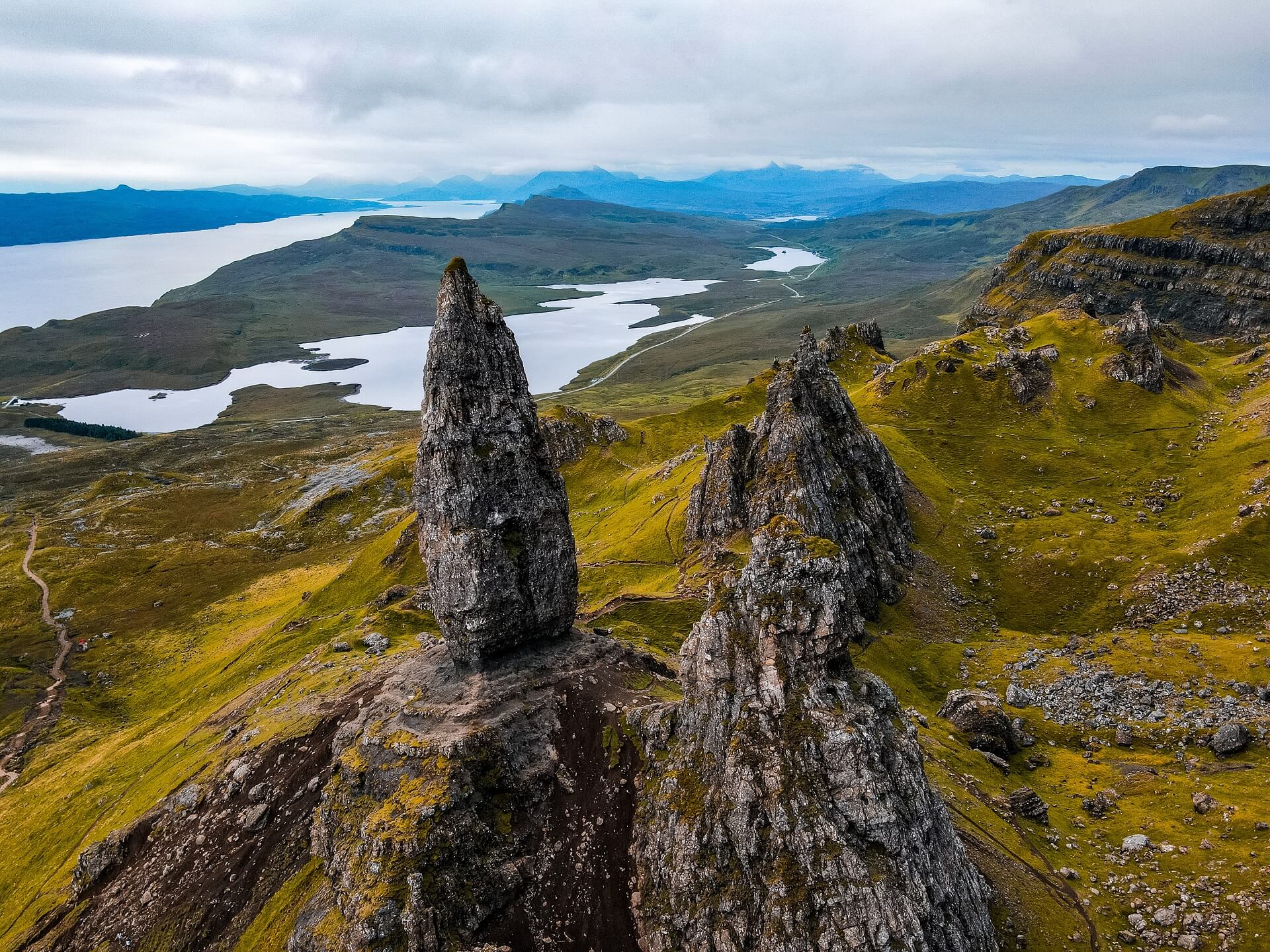
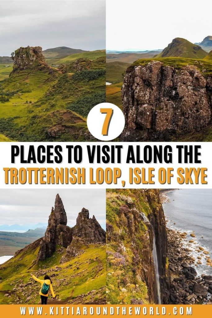
1. Circular Walk Around the Old Man of Storr
About the Old Man of Storr
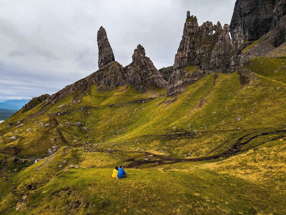
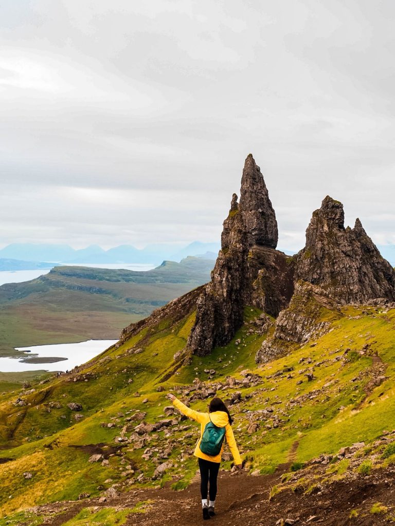
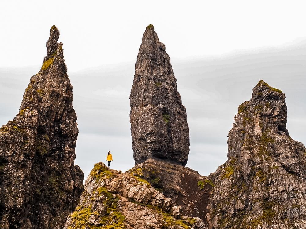
One of the finest examples of the Trotternish landslip is the well-photographed Old Man of Storr. It is hard basalt rock which was once part of the Trotternish Ridge. As you’ve probably guessed, a massive ancient landslide created the Storr which got detached from the ridge. It is very similar to how Alport Castles was created in the Peak District National Park in England.
The large pinnacle of rock that stands so high that it can be seen for miles around is the ‘Old Man’. Together with the Storr, they’ve created probably one of the most photographed landscapes in the world. Therefore, it’s probably the No.1 place on most road trippers Trotternish Loop itinerary.
How to get to the old Man of Storr and Where to Park?
Old Man of Storr is located approximately 7 miles to the north of Portree. It takes about 15 minutes to reach Old Man of Storr Car Park (SatNav: IV51 9HX) which is located just off the A855.
There are quite a few parking spots available but since this place is a tourist hotspot, it can become super busy especially during the summer holidays.
Up to 3 hours costs £3, up to 6 hours costs £5 and up to 12 hours is £7. You can only park here for up to 12 hours maximum. For reference we went for the 3 hours parking fee and that gave us enough time to complete our planned circular trail.
Facilities – The car park also has toilet facilities which is great.
Old Man of Storr Circular Trail
There are plenty of routes you can take that criss-cross around the Old Man of Storr. We chose a 5km (3 miles) circular trail which looks more like a figure of eight.
Please Note – This walk might be short, but it’s very steep and involves a ton of steps. Therefore, make sure to wear comfortable and supportive footwear. I saw quite a few people on our way back in heeled boots.
This route starts from the car park. After going through a gate you can take the nice, wide path. It’s very easy to follow. When you reach your first crossroads, carry on straight ahead instead of taking the path on your left. There will be a gradual ascent at the start which will turn a lot steeper later on.
As you climb higher and higher the views will also get better, so make sure to turn around and admire them. Soon you’ll arrive to another crossroads. Again, just carry on straight ahead towards the Old Man of Storr. This section will feel relatively flat for a while. You’ll reach another gate shortly where the path turns into many, many steps the rest of the way up.
Fun Story – There was actually an old man (pun intended) climbing up in front of us. He was definitely an inspiration and kept me moving up the steep steps.
Once you’re at the top you can just walk around the pinnacles, have some coffee and enjoy the views. Once you’re ready, circle back around the Old Man and head back down via the steps.
You can take the slightly less steep path on your right which circles around a bit before it joins with the path to the car park.
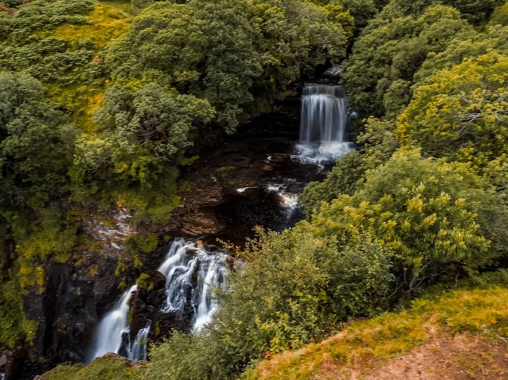
2. Stop by at Lealt Falls
Located approximately 5 miles from Old Man of Storr are the beautiful Lealt Falls. The waterfall lies in Lealt Gorge where the River Lealt runs from the Trotternish Ridge all the way to the sea. The colour of the water might look a bit orange due to the peat.
Where to park? – Free parking is available at Lealt Falls Car Park (SatNav: IV51 9JW) just off the A855. It takes less than 10 minutes from Old Man of Storr to get there. You can enter the car park via the laybys and then drive to the main car park.
From the layby there’s a newly built viewing platform where you get a great view of Lealt Falls. Both the car park and the viewing platform were built in 2018 by the Staffin Community Trust. This investment made the waterfall more accessible and safer to view.
The waterfall looks amazing especially after heavy rainfall. The combination of the falls with the Trotternish Ridge in the background is definitely picture worthy.
If you’d like to spend a bit longer in the area, you can take the footpath to Invertote viewpoint from the main car park. It runs along the gorge all the way to the sea providing you with some great views.
Did you know? – This beautiful area was once an industrial hub. Local people worked here between 1900 and 1960 digging and dying diatomite, more commonly known as chalk. It was extracted at Loch Cuithir and it was treated by the shore before it was shipped away. From the viewpoint you will see the remains of some buildings and the railway line that ran parallel to the gorge.
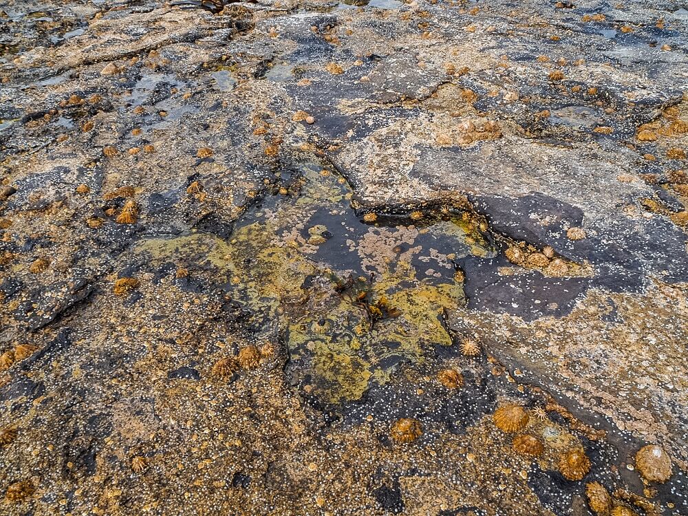
3. Go Dinosaur Footprint Hunting
Have you ever wanted to see evidence of dinosaurs outside the museums? If so, then make sure you go dinosaur footprint hunting during your road trip along the Trotternish Loop.
Skye is known to be an important place for researchers since a great percentage of mid-Jurassic discoveries have been made on the islands. Those sites house footprints that belonged to the massive long-necked, plant eating sauropods. In 2018, palaeontology students discovered at least 50 footprints dating back 170 million years at Brothers Point. Apparently some of them are as big as a car tyre!
And what’s even better is that some of these footprints aren’t just from sauropods. They also discovered footprints that were three-toed and belonged to meat-eaters, possibly theropods.
Both two- and four-legged dinosaurs left their footprints behind as they walked along the shallow lagoon which was once a warm tropical place.
Useful Information Before You Go Dinosaur Footprint Hunting
Where to park? – Less than 1.5 miles to the north of Lealt Falls is Brothers Point Car Park (SatNav: IV51 9JH). You can park at the layby for free and visit Brothers Point and go dinosaur footprint hunting from there.
Where are the dinosaur footprints? – AllTrails shows that the footprints are at the edge of Brothers Point. However, the signs at the start of the trail say that they should be in the little bay area before you even get to Brother’s Point. I think the latter is the right place. See detailed trail description in the section below.
Best Time to Visit – The area where the footprints should be can be under water during high tide. You want to check tide times and come during low tide. Also be aware that the tide comes in quickly so you don’t want to get stranded!
Please Note – Just to avoid any disappointment, you may or may not find any footprints. They won’t just be there with a big sign saying ‘Hey, I’m a dinosaur footprint come and take a photo with me’. You really have to search for them. Which, trust me, isn’t easy when every pothole and pock mark looks potentially like a footprint.
We spent at least half an hour trying to search the area as much as we could. I think towards the end I started to imagine seeing footprints. I quite likely even walked past a few.
Top Tip – You can Google some photos which can give you a general idea of what they should look like.
Since the tide was coming in fast we gave up our hunt and headed toward Brothers Point. It was still a fun activity to do on the road trip.
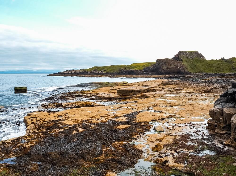
4. Discover a Hidden Gem: Brothers Point
About Brothers Point
If you enjoy dramatic landscapes that aren’t super popular yet, then adding a short hike to Brothers Point is a must on your Trotternish Loop itinerary.
Also known as Rubha nam Brathairean, this stunning headland offers some fantastic views along the coastline. My internet search behind the name led me to Staffin Ecomuseum’s website which briefly describes a few possible stories as to why this place is called Brothers Point.
According to the website the name could come from monks who possibly lived a simple life here back in the 6th century. However, ‘Brothers’ could be referring to those who lost their lives when their ship wrecked here back in the 19th century.
One thing that is for sure is that archaeologists have found signs of hunter-gatherers, Iron Age warriors, Medieval monks, clan chieftains and crofter-fishermen on the Trotternish Peninsula.
Although Brothers Point’s history is a bit of a mystery, this beautiful landscape is totally worth exploring.
Useful Information About the Brothers Point Hiking Trail
Where to park? – Limited free car parking is available at Brothers Point Car Park (SatNav: IV51 9JH).
Length of the trail – 3.3km (2 miles)
Level of difficulty – Easy to moderate (depending on level of fitness and hiking experience). The hike includes some steep sections and narrow paths.
Facilities – There are no toilets along this hike.
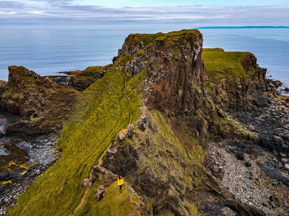
Brothers Point Point-to-Point Walking Trail
After you’ve parked, cross the A855 and head south towards the trail head. It should be on your left and sign posted as Rubha nam Brathairean. Make sure to be careful when walking along the side of the carriageway as this is a busy road.
Just follow the track which will pass a holiday lodge and some information boards with a map of the trail. The path is easy to follow as you just have to walk all the way down to the beach. This beach section is where you want to stop for a little dinosaur footprint hunt.
From there just pass the stream and continue along the shore. This section might be a bit boggy and the path won’t necessarily be clear but don’t worry and just carry on towards Brothers Point. Soon you’ll get to a narrow dirt path that takes you a bit higher and will provide you with stunning views of Brothers Point.
You can walk all the way out to the edge of Brothers Point. The trail is a bit narrow and might not be for everyone. It’s a steep climb to the top and a pretty steep descent too which you’ll have to repeat on your way back.
Top Tip – The grassy part at the end is a great place to have a picnic with stunning views all around you.
Since it’s a point-to-point trail, you’ll just have to walk back the exact way you came. Whilst this area is slowly getting busier, possibly thanks to the dinosaur footprints that were found in the vicinity, I think it’s still a much quieter spot than Old Man of Storr or the Quiraing.
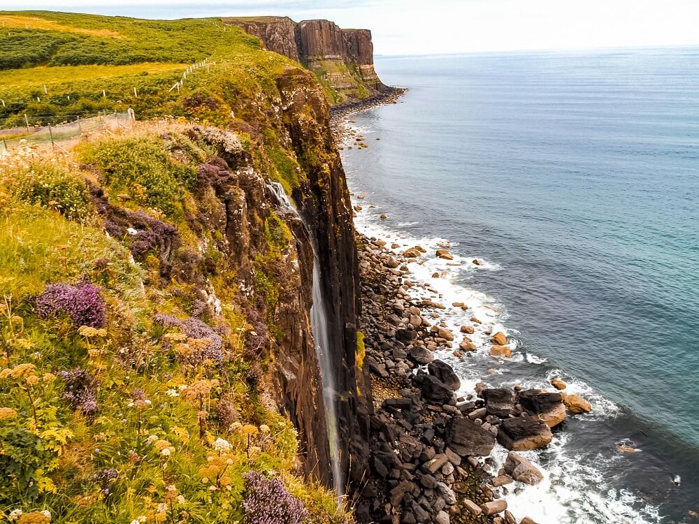
5. Admire the Views of Kilt Rock and Mealt Falls
Your next stop on the Trotternish Loop should be Kilt Rock and Mealt Falls viewpoint.
Kilt Rock is a 60m ancient cliff which resembles a pleated kilt with its vertical basalt columns. Mealt Falls is an approximately 55m waterfall that cascades straight into the sea from the cliff. This beautiful waterfall is fed from Mealt Loch located just across the road from the viewpoint.
Where to Park? – Approximately 2 miles to the north of Brothers Point is Kilt Rock Viewpoint Car Park (SatNav: IV51 9JE). You can park here for free.
There’s only a viewing platform from which you can admire Mealt Falls and Kilt Rock behind it. So, you won’t be able to get too close to the falls for obvious safety reasons.
Did you know? – Apparently during strong winds the man-made holes in the safety fence can create an organ-like musical instrument by the wind blowing through them. Unfortunately, it wasn’t windy enough on the day of our visit to experience this sound.
Note – As you can see on the photo, there wasn’t much water cascading into the sea when we visited. I’m sure that the waterfall would look a lot more impressive after heavy rainfall. Regardless of the strength of the waterfall, it was still a great place to stop at. Also, seeing Mealt Falls dropping into the sea reminded me of our trip to Madeira in Portugal.
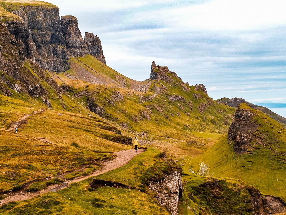
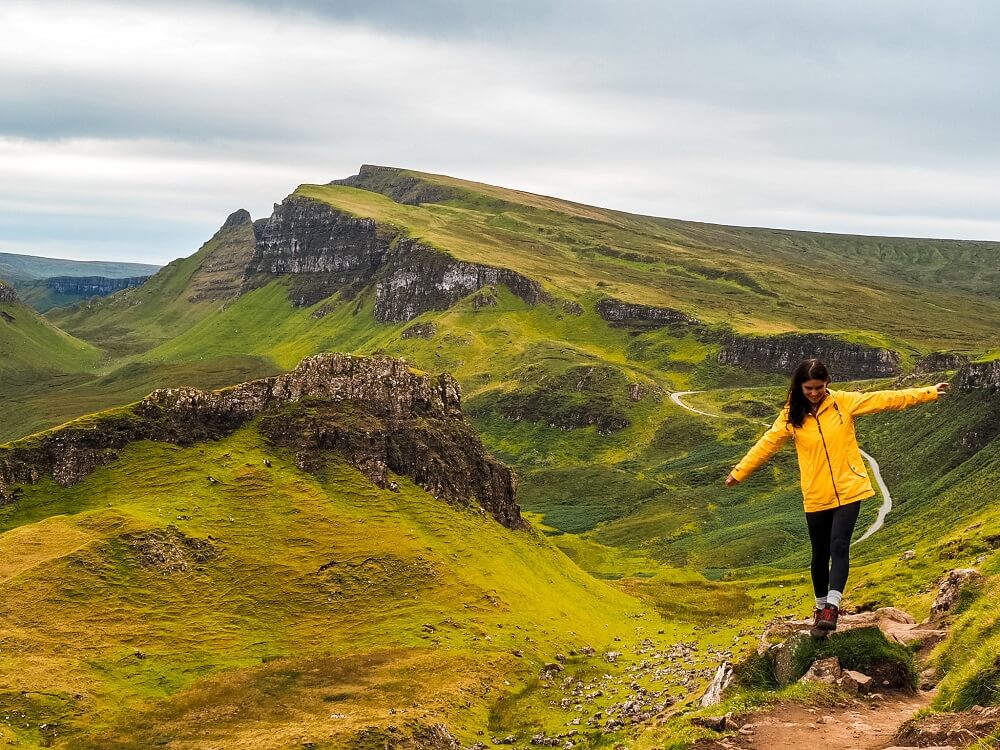
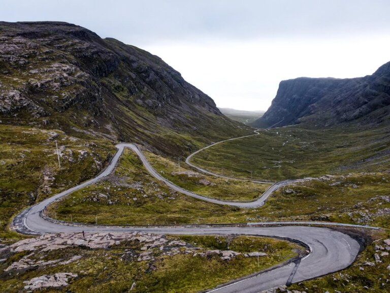
6. Explore the Quiraing
About the Quiraing
Exploring the Quiraing should be very high on your list of places you’d like to visit along the Trotternish Loop.
As I mentioned above, the Trotternish Ridge was created by landslides. Therefore, the Quiraing, just like Old Man of Storr, is also part of this landslide. However, what’s more unique about the Quiraing is that it’s the only part of the landslide that’s still moving. The proof of this is that the road at its base requires constant repair. Although it’s much larger in scale, the area reminded me a lot of Mam Tor in the Peak District National Park in England.
Did you know? – Its name comes from the Norse (Nordic or Scandinavian) language meaning ‘Round Folds’. Apparently, highlanders used to hide their cattle within the Quiraing from Viking raiders.
How to Get to the Quiraing and Where to Park?
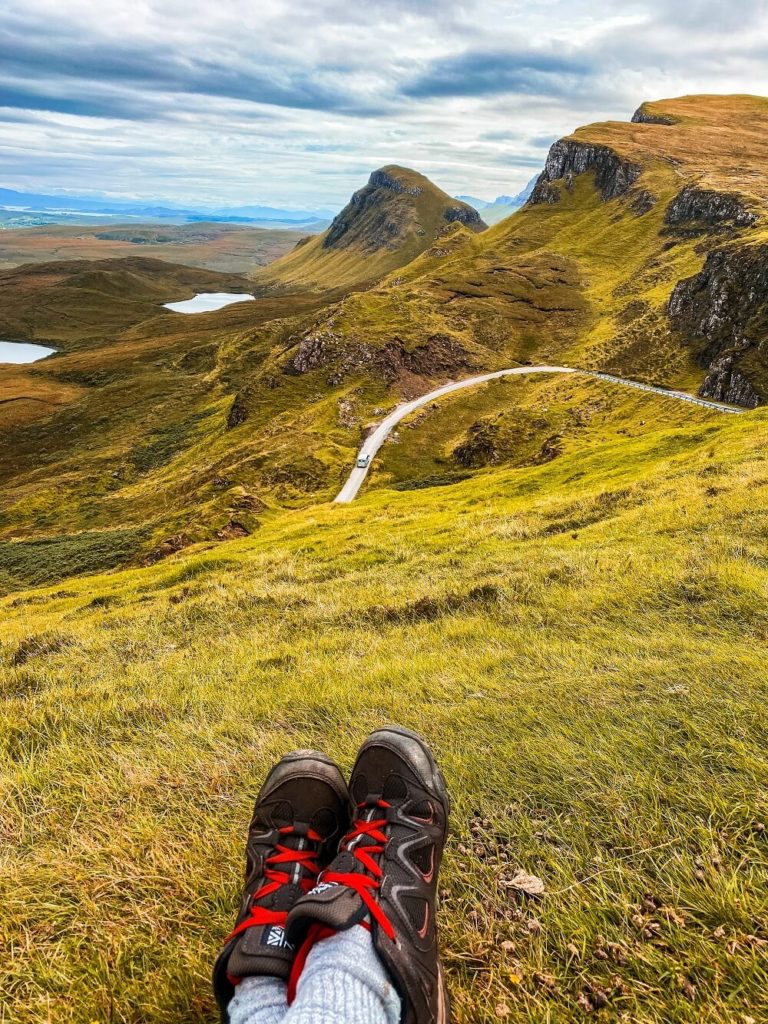
The Quiraing is located approximately 2.5 miles from Staffin along the small road that connects Staffin and Uig. After leaving Kilt Rock and Mealt Falls viewpoint drive to Staffin by following the A855 north. Turn left onto the small road signposted to the Quiraing. You’ll have to follow this road until you reach the car park.
Where to Park? – You can park at the Quiraing Car Park (SatNat: IV51 9LB). The car park is open from 8am to 8pm but you can only stay up to 6 hours. You can either buy a 3 hour stay for £3 or a 6 hour stay for £5. If you’re planning on hiking the full circle I recommend getting the 6 hour stay.
Facilities – There’s a small food truck at the car park, selling warm and cold drinks and some food such as hot dogs and burgers. We were pretty tempted to grab something because it smelled very nice but then decided not to in the end since we had our own snacks. Please note that there are currently no toilet facilities available at the car park.
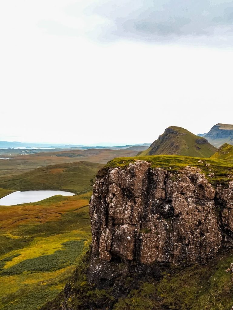
The Quiraing Point to Point Walk
As you’ve probably guessed, the Quiraing gets very busy with tourists. However, what I noticed was that many of them only stop here briefly to take pictures before moving on to their next stop. Therefore, the immediate area around the car park might look packed but once you start walking along the footpath it’ll be less busy.
Whilst the landscape itself will leave you speechless, there are some interesting features further away which are worth seeing. To see them, you can either do a 4km (2.5 miles) point to point walk, or opt for a longer circular one.
The path is very straight forward and easy to follow. Once you cross the road at the car park just follow the footpath straight ahead. At the crossroads carry on along the lower path. The path itself is a bit narrow and can be uneven, so wear sensible shoes. It is however pretty level, so it’s a lovely walk through a stunning landscape.
Towards the end of the footpath before it starts splitting, you’ll notice two interesting features. One of them should the Prison which is a pyramidal rocky peak that looks like a medieval keep. The three-peak summit from the right angle can look like a prison.
Just across from the Prison is a 37m high pinnacle called the Needle. The similar looking pinnacle to the Old Man was also naturally created by the landslide. After checking out these features, you can either return the way you came or walk a bit higher up, following the footpath past the Needle to see another feature called the Table. It’s basically a flat and grassy area that’s just slipped down from the summit plateau and resembles a table.
If you have a bit more time, I highly recommend completing the full circular walk. Since we still had one more place on our Trotternish Loop itinerary for the day, we had to say bye to this stunning landscape earlier than we would have liked.
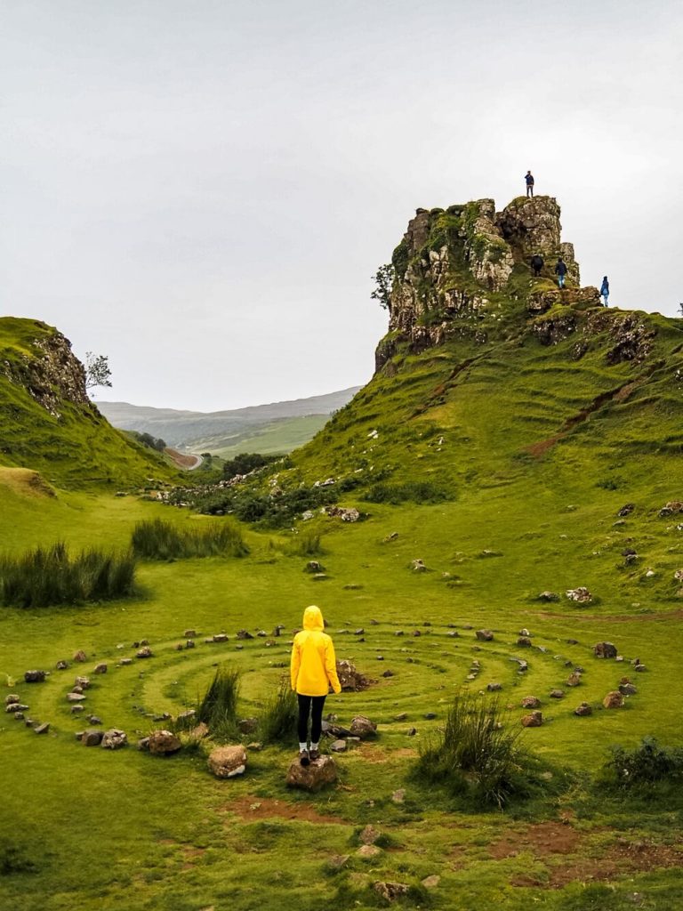
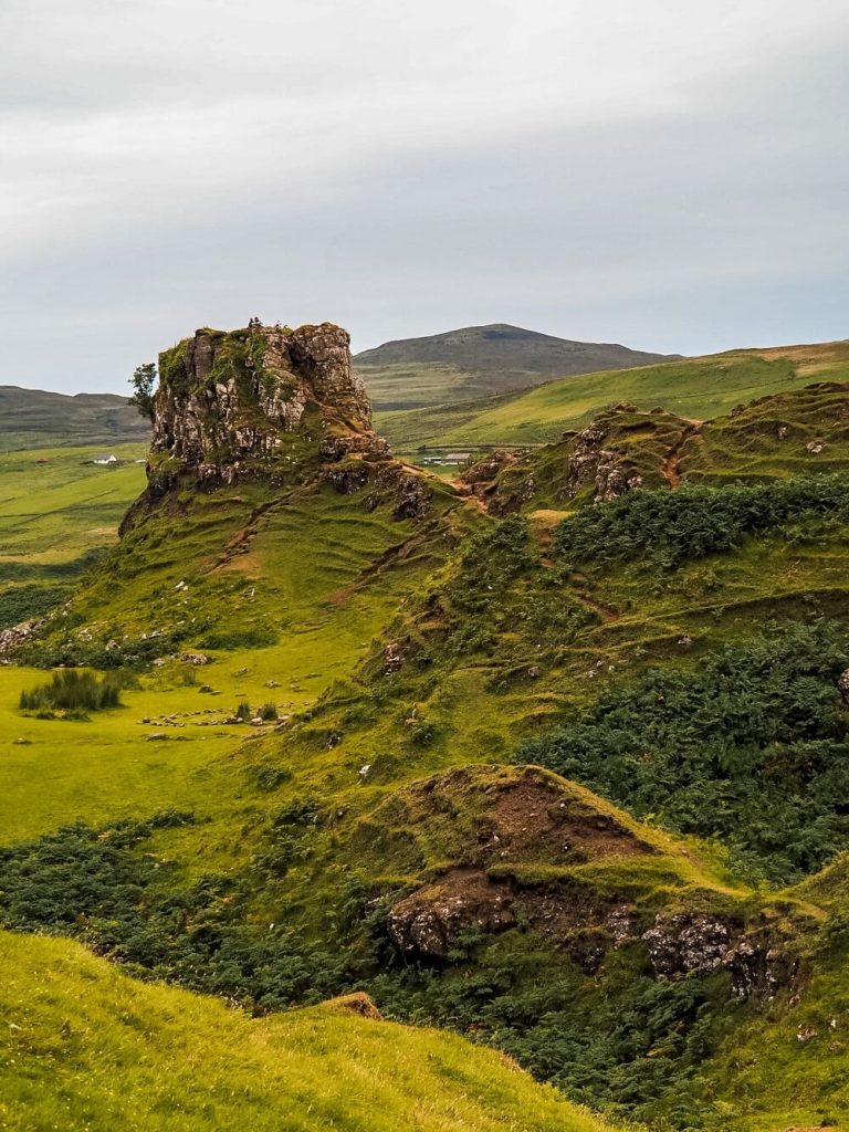
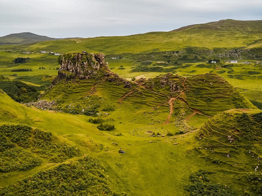
7. Wonder Around the Mysterious Fairy Glen
The Fairy Glen is another stunning area that’s on most road trippers itinerary along the Trotternish Loop. It looks almost like a miniature version of the Quiraing.
You might be wondering about the Fairy Glen’s name and its relation to fairies. Whilst Skye has quite a history involving fairies, my internet search didn’t reveal any traceable legends linking them to the Fairy Glen. The most likely explanation for the given name is that this place is just so lush, mysterious and magical that it gained the name Fairy Glen.
How to get to the Fairy Glen? – After leaving the Quiraing, follow the narrow road that cuts across the peninsula all the way to Uig. Just after passing the Uig Hotel, turn left onto the small road where the road sign points towards Sheadar and Balnaknock.
Where to Park? – There’s limited parking available at Fairy Glen Car Park (StaNav: IV51 9XX). You can either get 2 hours for £2 or up to 4 hours for £3. Alternatively, you can park in Uig.
Fairy Glen Circular Walking Trail
From the car park take the footpath that runs parallel to the road. The path will lead you back to the road which you have to cross. You should be walking past a small pond with the path climbing a bit higher up. This will circle around Castle Ewen which is a rocky prominence. You can climb up to Castle Ewen to get some beautiful views over the area.
Please Note – At the final bit of the climb to the top of Castle Ewen you’ll likely have to squeeze yourself between the rocks.
Just across from Castle Ewen is where the stone circle is located that you’ve probably seen on many photos before. Obviously this wasn’t the work of fairies, rather it was arranged by tourists. Some websites mentioned that some guided tours encourage people to circle around the rocks and leave a coin in the middle for good luck. Feel free to circle around the spiral but please DO NOT leave a coin, or anything else for that matter, behind. It’s bad for the environment!
You can climb up and down some of the surrounding hills to get a different perspective on the area. Once you’re ready to leave just walk back to the car park. Once you’re back at your accommodation you’ll have completed the picturesque Trotternish Loop.
Additional Things to Do on the Isle of Skye
In order to see everything the Isle of Skye has to offer, you’ll need at least 3-days. So, if you’re planning your ultimate road trip, make sure to check out other places to visit during your trip:
7 Things to See in Central Isle of Skye – A 1-day road trip itinerary in Central Isle of Skye including a circular trail, a picturesque bridge, waterfalls, highlands cows and more.
Things to See in North-West Isle of Skye – Discover the north-west area of the Isle of Skye during a 1-day road-trip.
In the meantime, you can also browse for more Scotland content or more hiking trails in the UK and around the world in my Hiking Adventures Series.
Final Thoughts on the Trotternish Loop
I definitely saw many Trotternish Loop itineraries online that packed a lot more into one day. Whilst it would’ve been lovely to see other places such as Duntulm Castle or the most northerly point of Skye, Rubha Hunish, I know that we would’ve felt rushed. Therefore, picking a few places where I wanted to spend longer and stopping briefly at others that were on the way was a great mixture.
I was definitely amazed by the landscape’s rugged beauty and not surprised that these places are well visited. Although we still had one more day on the Isle of Skye, I instantly knew that this part of the island would be my favourite area of all.
Have you ever driven along the Trotternish Loop or visited the Isle of Skye before? If so, tell me about your experience and how much of the area you managed to explore? Let me know in the comments below.
Now, let your adventure begin,

Our Top Travel Resources
Accommodation: For hotels we always use Booking.com and Hostelworld for hostels. We also book longer stays on Airbnb or Vrbo.
Flights: To find the best flight prices we always check Skyscanner, Google Flights or WayAway. Then we also check the airlines’ websites too for comparison.
Car Rentals: We use Discover Cars when we want to rent a car as it compares local, national and international companies.
Activities: If we book organised tours we always check either GetYourGuide or Viator.
Foreign Currency: Whenever we can we prefer to pay in local currency and for that we always use our Wise card. We can easily withdraw money from the ATM or pay by card at most shops and restaurants.
Travel Insurance: We never go anywhere without travel insurance. You never know what will happen on your trip, so good travel insurance like SafetyWing can protect you in case of injury, illness, theft and cancellations.
eSIM and VPN: To get data abroad we use Airalo which is an app that allows you to download a prepaid eSIM to your phone in over 190 countries. Make sure to have a VPN to avoid hackers accessing your personal data when using public WIFI. We use Surfshark which is the only VPN that offers one account on unlimited devices.
Remember…It all starts with a Pin…
Okay shut up the fairy glen is so cute:’) And you’re seriously making me want to invest in a drone!! I love the fact that you’ll probably run into the same people every day- I absolutely love meeting like minded people and sharing special moments with complete strangers:)
Thank you Emma, I agree the Fairy Glen is really adorable. We also enjoyed bumping into the same people it was quite fun. Hope you can visit Skye soon.
This blog needs to get some more love for a number of reasons;
1. The incredible and detailed information you’ve taken to share with your readers.
2. Fantastic tips and advice that is easy to follow.
3. STUNNING photos which will inspire anyone to go to Skye immediately.
4. I need to go hiking.
I absolutely loved this blog and your series on Skye. Its so informative and I will be earmarking this page and returning to it in hopefully 2023!
Thank you so much for the lovely comment Missy. I’m so happy that you enjoy my Isle of Skye series. I hope you can come and explore it in 2023.
I actually didn’t know about this place; asking myself how that’s possible?? because this looks so beautiful! Absolutely love your photos! This guide is honestly perfect so I’m definitely saving it for future travels to Scotland!
Thank you so much, I’m so happy that my post inspired you to travel to Skye in the future.
Wow this area seems absolutely dreamy! I’m honestly not too familiar with Scottland, so this post was super helpful and thorough! This place is now at the top of my list
Thank you Destiny, I’m glad you enjoyed my post. Hope you can visit in the near future.
My husband and I love to hike. These are beautiful hikes with some very instagrammable features along the way. Nice to see more of Scotland.
If you both love to hike then I’m sure you’d love Skye and Scotland. There are endless hiking trails with some of the most amazing views I’ve ever seen.
I wish I had these tips the last time i went to Skye! We saw a few of these spots but didn’t manage to go on a proper hike due to the very bad weather. The electric car we rented also couldn’t travel too far from a charging point!
I’m sorry to hear that you couldn’t visit a lot of these places due to bad weather and the electric car. I hope they will improve the number of charging points in the near future and you can return to Skye.
Skye has been on my bucket list for sooo long! I will now add these 7 places on my bucket list!
Skye is so beautiful, I’m sure you’ll enjoy your visit very much.
When we plan our long visit to the UK, I am definitely adding the Isle of Skye for a long visit. The Trotternish Loop looks like a great spot for some beautiful landscapes. Great to know we could see all 7 stops in one day. But we will head out early to give us lots of time for stops.
I can’t recommend a visit to Skye enough. The landscape along the Trotternish Loop is truly beautiful. I hope you can visit soon.
dinosaur footprint hunting is a thing!?? sign me up please this all sounds so cool!!
Haha, yes we went on a little hunt on our own, but unfortunately we couldn’t spot any. Although we probably walked past a few. Hope you’ll have better luck when you visit.
You have inspired me to add Isle of Skye to my list! I would love to hike and explore all seven of the beautiful places you recommend on the Trotternish Loop. Beautiful!
I’m so happy to hear that my post inspired you to visit Skye. I’m sure you’ll enjoy your visit very much.
This guide is incredible! Wow, how I would love to see Lealt Falls and the Fairie Glen – both look so enchanting and magical. The Isle of Skye is very high on my list and hoping to visit Scotland next year – so saving this for inspiration. Thank you!
Thank you Daniella, I really hope that you can visit Skye next year. I’m sure you’ll love these spots along the Trotternish Loop.
Exploring Trotternish loop looks like a magical trip! I’d love to see Old Man of Storr, the landscape looks incredible! Mealt waterfall looks beautiful too. The Isle of Skye looks like a wonderful place to explore. Thanks for the great guide!
Thank you Hannah. I’m pretty sure that you would enjoy your Isle of Skye visit. I hope you can plan a trip soon.
Scotland is always so beautiful! Great suggestions for places to visit.
Thank you so much Kez.
What a post! Such amazing photos and great attention to detail. I always appreciate when people include where to park!!! Helps eliminate so much frustration..one day I will get here!
Thank you Jennifer I’m happy that you found my post useful. I hope you can visit Scotland soon.
What a fantastic place to visit. You have made we want to re-visit Skye again. We completely missed this peninsula last time we went. I loved the shots of Brothers’ Point and the history surrounding it. Look forward to seeing it for myself some day. x
Thank you Karan, I’m glad that my post made you want to re-visit Skye. There are so many amazing spots on this part of the island that I’m sure you won’t run out of things to do. x
Holy moly, your photos are incredibly inspiring! Thanks for such an awesome guide!
Thank you so much, I’m so happy to hear that you enjoyed my photos.